This is a log of the changes that have taken place with each release of Gilbert 21.
Added an iNaturalist format option to the export functionality. This will export into
a CSV file with header names matching those described
here:
https://www.inaturalist.org/observations/import#csv_import.
There is also a new export for RODIS - "RODIS Excel" - which outputs into Excel 97-2003 format (.xls),
rather than CSV, and has
minor changes to header names.
Added an iRecord format option to the export functionality. This will export into
a CSV file with header names matching the defaults template downloadable from
here:
https://www.brc.ac.uk/irecord/import-records. There is one exception - the
comment column header has been changed from 'Sample comment' to 'Occurrence
comment' since the comment in G21 pertains to each individual record rather than
a sample.
The G21 fields 'Location' and 'Town' are joined (separated by a comma) under the
iRecord 'Site name' import column. Similarly the G21 'Abundance' and 'Units'
fields are joined (separated by a space) under the iRecord 'Quantity' column.
Fixed an issue (https://github.com/burkmarr/Gilbert21/issues/2)
with the incorrect reading of geolocations from photographs when longitude
greater than zero degrees but less than one degree (east of Greenwich Meridian).
Fixed an issue with incorrect handling of taxonomy retrieved from the NBN Atlas
where some taxonomic ranks had no value (https://github.com/burkmarr/Gilbert21/issues/1),
causing some search results not to appear. Also improved the display of search
results by separating 'exact' from 'fuzzy' matches and making sure matching list
always scrolled to top when first presented to user. Also enabled users to
select higher level taxa and populate scientific name field from this.
Update to migrate the taxonomy search from the old NBN Gateway taxomony web
service to the new web service provided by the NBN Atlas.
The NBN Atlas does not support the old taxonomy groupings used by the NBN Gateway
and utilised by G21 for grouping taxa. So if you are adding a new taxon to your
local dictionary by searching the NBN Atlas taxonomy, you will now need to
assign the taxon group manually - either selecting from the drop-down list of
taxon groups that you've already used, or typing a new one yourself.
The ability to view a distribution map from the old Gateway WMS has been
disabled.
Gilbert 21 is now open source. The GitHub repository is here:
https://github.com/burkmarr/Gilbert21
Bug fix to cope with variations in Visiontac CSV file format.
Bug fix. Gilbert 21 desktop had a bug that meant when opening files from the
G21 Android App, it confused unique date/time stamp and associated some files
with existing records. The bug would only have been evident if you used one of the
new filename formats (Simple OSGR or Simple Lat Long).
Bug fix. Minimising form sent G21 to system tray even when 'Watch' option not checked. This
release addresses that bug.
Bug fix. When the NBN Rest Taxon Dictionary was used to select a dictionary entry with no common name
(e.g. Sternus vulgaris or Larus argentatus) G21 set both common name and scientific name to a blank value.
This fix addresses that. Note that, for both of the examples given, the NBN taxon
dictionary does not associate the expected common names with the scientific
names (Starling and Herring Gull). This is probably because those species are
split into sub-species in the dictionary. You can still associate a common name
with such a scientific name by specifying the common name manually (it will be
remembered in the local taxon dictionary).
New release whose main purpose is to update Gilbert 21 to use the new NBN
Rest services in place of the old SOAP services which are due to be retired
early in 2015 (e.g. for the Taxon dictionary). Other major changes were
introduced to streamline the integration of G21 desktop with the G21 Android
App. These include:
- Change to enable G21 to remember, from one session to the next, the
filetype option selected for opening files. So, for example, if 'Gilbert 21
sound files' files is selected, then this will be remembered until the next
session so that the user does not have to reset it.
- Added an option - a 'Watch' checkbox next to import folder location - which, when
checked, will cause G21 to intercept requests to quit or minimise the main form
and keep the application open - putting a G21 icon in the system tray. G21 then
checks the import folder every 30 minutes and pops up a message informing the user if there are any files waiting for processing. To quit the application when this option is selected,
use the new 'Exit Gilbert 21' item from the 'File' menu.
- Added a new option - 'Folder for processed' - which stores the location of a folder
into which files in the import folder - which relate to currently opened records
- can be automatically moved using a new tool button on the main form.
Optionally, if the 'Delete' checkbox next to this folder optio is checked,
such files are deleted rather than moved when the tool button is pressed. These
options allow users to manage imported files without resorting to external
tools such as Windows Explorer.
- G21 Desktop can now handle files generated by the new Android App - whatever
filename format is chosen on that device.
Several minor enhancements were introduced and problems addressed in response to
user feedback. These included the following:
- Occasionally Visiontac/Columbus devices can produce corrupt rows in the CSV
files they generate. This used to cause G21 to fall over on import, but now
these errors are handled more gracefully.
- Phenology graphs were falling over when they came across records with bad dates
(which can be introduced into the database when importing records without using
the core G21 tools).
- When KML files (for Google Earth) were produced containing records with
ampersands in the common name (e.g. 'Heart & Dart') the KML files produced were
invalid. Now ampersands have been 'escaped' in the KML files produced so that
they are valid.
- The option to removed sounds from records has been expanded so that now more
than one record at a time can be handled.
Released first version of G21 app for Android.
It is available as a download via this website and is not
yet released via the App Store.
Implemented a small change to cope with a change in the Evernote export format between
Evernote 4.x and 5.x.
Implemented some minor enhancements: field visibility options are now remembered between
sessions; polygon filter files can now be KML files exported from Google Earth. (The
KML file must contain a single polygon.)
Added new export format - BirdTrack Casual - to enable export into format suitable for
bulk upload into BTO's BirdTrack. Updated the online help to document this new
feature.
Bug fix to overcome problems experienced by new users before a database is set up. Gilbert 21 now handles
this situation better and gives better guidance on where to find help to set everything up.
Added phenology graphing capability. This new feature takes advantages of graphing capabilities
of the .NET framework version 4. Read more about it here:
HelpHTML/Gilbert 21.html.
Fixes to bugs on export functionality. Adds capability to append to existing
exports of type 'None'. Improved features for KML output files for Google Earth
export and Google Earth quick view, including optional 'atlas' style distribution layers for exported records.
Introduces a new suite of functionality to track exports and export recipients and to
keep an export history for each individual record. Also migrated from version 3.5 of
the .NET framework to version 4.0. Gilber 21 itself has moved to version 3. This
will not upgrade automatically from version 2. To install version 3, you must
install it from
version3/publish.htm.
Adds new record open functionality to select records based on their export history
and who they have been sent to. This complements the new export history functionality.
In addition, the different methods of opening (selecting) records have been integrated
into a single dialog where the four methods can be used in conjunction.
Added a new tool-button to remove records from the records displayed on the main
form without removing them from the database. This helps with preparing records for
export.
Removed the option from the record properties dialog to omit record checking for a
record and, at the same time, made it possible to save 'invalid' records to the database.
Added functionality to the options dialog to make the colours of records displayed on the
main form user-selectable. Also changed the way that records marked to be excluded from
exports are coloured on the main form. Instead of changing the record colour, these
records are now highlighted by changing the colour of the record header column (the column
where the records are sequentially numbered) on the main form.
Added a new ability to import Evernote ENEX export files. This overcomes a problem
introduced in November 2012 when Gilbert 21's direct connection to Evernote notebooks
stopped working due to a change in security policies introduced by Evernote.
Added a new option on record details form to map associated track of currently selected
record.
Added a new option on record details form to map the locations of other records currently open
on main form.
Changed default handling of Visiontac/Columbus files so that
candidate records are only generated from voice tags. This can be changed
to make candidate records from all tags - the previous behaviour - by setting an
option on the options form.
The current database folder is now displayed on main form so you can be sure what database
you are updating if you have more than one.
During the importing of multiple files, the name of the currently importing file is
now displayed to the right of the progress bar.
Accounted for bug whereby totally empty CSV files - which are sometimes producted
by Visiontac/Columbus for some reason - caused a crash.
No longer any need to rename non-Visiontac/Columbus CSV import files so that they have
a different file extension to '.CSV' (e.g. '.txt'). They can now be left as CSV files -
Gilbert 21 will recognise that they are not Visiontac/Columbus files. No longer
need to rename import fields called 'Date' and 'Time' to 'RecDate' and 'RecTime'
respectively - Gilbert 21 will treat fields called either 'Date' or 'RecDate' as
a field containing the date and fields called either 'Time' or 'RecTime' as a
field containing the time.
Upgraded NBN taxon search to use version 3.5 of the NBN Gateway web services
(was version 3.1).
Added tool-tips to NBN species distribution map dialog.
Fixed bug that caused unsaved edits to be lost even when user asked for them to be saved.
Modified code so that Gilbert 21 does not crash when opening a Visiontac/Columbus file
for which the association sound (WAV) files cannot be located.
Added facility to view NBN species distribution maps over the Bing/Google maps
displayed on Where tab of Record Properties form (see
NBN Mapping).
Updated documentation for the Where tab of the Record Properties form.
Put error traps into code to deal with instances where Gilbert 21 can't open
an external program (e.g. a browser or Google Earth) for some reason.
Added stdole.dll to the distribution to overcome a reported installation problem.
Added option to export records in the format required for importing into the
RODIS on-line recording program. The export function outputs a CSV file which you
must open in Excel and save as an Excel workbook (*.xls file extension)
before it can be imported to RODIS.
Fixed a bug with the polygon selection function of previous versions. This bug
could cause records outside the selection polygon to be incorrectly selected or, in
some cases, caused some records within the selection polygon not to be selected.
There was a bug with the previous installation file (due to a problem with the Microsoft
ClickOnce installation builder) which meant that it didn't build properly and
would not install Gilbert 21 on some machines (noticed first with Vista OS). This
new build was produced to correct that problem.
Introduced a new internet-based help system built with HelpNDoc. Using this tool
a professional help system can be implemented which supports keywords, text searching
and all the usual features. The contents of the help system can now be more easily
systematically compiled and added to. The new help system can be reached through
the Help menue from Gilbert 21 itself or from the Help link at the top of the
website pages.
Improved the way Gilbert uses 'ffplay.exe' for playing AMR audio files from Evernote
mobile phone apps.
Added an option for Evernote users to use ffplay.exe to play their AMR sound files
from Evernote if they wish. This is useful for users who are having trouble playing
AMR files in other ways. To use the facilty, download
the relevant ffplay.zip file,
unzip to a convenient location on your computer and then set the 'Ffplay executable'
option on the 'Data options' tab of the options dialog to the full path of this
file.
Added a facility for searching the OS 1:50,000 gazetteer for a place name from the
Where tab of the record properties dialog. This is useful if you are entering records
without any GPS grid reference. You can search for a location in roughly the right
place then use a bing or google map to locate the exact grid reference.
Improved the panning behaviour for Bing and Google maps.
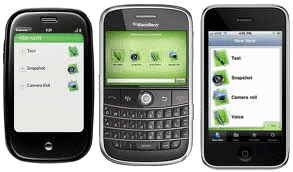 Added ability to use Evernote notes to create records. This means that Smart phones
can now be used to make records. To do this you need to install the Evernote app which
is free for iPhone, Blackberry and Android. You can then use your phone
to make notes from
a voice recording (in a similar way to the Visiontac data logger), from a photograph or
from a simple written note. The phone's
GPS is used to geotag the Evernote note and Gilbert 21 can derive the grid
reference from this.
Added ability to use Evernote notes to create records. This means that Smart phones
can now be used to make records. To do this you need to install the Evernote app which
is free for iPhone, Blackberry and Android. You can then use your phone
to make notes from
a voice recording (in a similar way to the Visiontac data logger), from a photograph or
from a simple written note. The phone's
GPS is used to geotag the Evernote note and Gilbert 21 can derive the grid
reference from this.
To use the feature, install the Evernote app on your phone and set up a free
Evernote account; then set your Evernote credentials on the options dialog. When
you have made some notes on your phone and synched them to your Evernote
account, you can select 'Open Evernote notebook' from the file menu in Gilbert
21 and open your notes to make records. The feaure will be
properly documented soon.
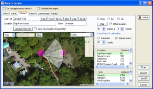 Added new mapping features on the 'Where' tab of the record details form. You can
now map a record directly on the Where tab using Bing Maps or Google Maps.
This is more convenient than using the Google Earth link. The best feature of
this is that you can click a point on a Bing or Google map and elect to use the
grid reference at the selected point for your record. So now you can really
quickly make fine adjustments to the grid references you collect in the field
where necessary.
Added new mapping features on the 'Where' tab of the record details form. You can
now map a record directly on the Where tab using Bing Maps or Google Maps.
This is more convenient than using the Google Earth link. The best feature of
this is that you can click a point on a Bing or Google map and elect to use the
grid reference at the selected point for your record. So now you can really
quickly make fine adjustments to the grid references you collect in the field
where necessary.
Note that Google maps and Bing maps may be subject
to certain usage limitations - for example you can only generate 1000 different Google map
images in the space of 24 hours (the limitations on Bing, if any, are less
clear). Since a new image is generated every time you pan or zoom
or otherwise change the image, you could bump up against this limit if you are using the
software a lot over the course of a day.
Note also that this new mapping facility and associated grid reference selection supersedes the
'calculate offset grid reference' (added 26th February) which is therefore removed.
The taxon group field on the record details dialog is now editable - previously
it was read-only. It now consists of a combo-box with all previously used taxon
groups appearing in the drop-down list. The taxon group can be changed/set by
selecting from the drop-down list or by typing in any value. (Note that new
values typed in here will only appear in the drop-down list after one or more
records with the new value have been saved to the database.)
Changed behaviour when enter key pressed in personal notes field of record
details dialog. Doing this now changes focus to dialog okay button. Line breaks
can still be entered in the personal notes field (and now in the comments field
too) by holding down the [ctrl] key whilst hitting the enter key
Fixed bug that sometimes caused a crash when grid reference precision reset on
'where' tab of record details dialog.
Fixed bug that sometimes caused strange behaviour - including setting
incorrect values for scientific and/or common names when either of these fields
was meant to be blank.
Removed the 'Open by polygon' item from file menu and added this functionality as
an additional filter on the 'Open by filter' dialog. This allows filters and
geographic selections to be used together - for example to select all birds within a given geographic boundary.
Added new page to the website with boundary file resources for download. These files
can be used with the 'Open records by polygon' feature.
Added new facility to calculate an offset grid reference from the GR recorded
by the GPS without recourse to Google Earth. This can be used from the
new 'Offset GR' button on the 'Where' table of the record properties dialog. This
can dramatically speed up record processing when offsets are regularly used.
Added a facility to enable new records to be initialised from a comma separated values (CSV) file
with any of the following fields (which must be specified on the first row):
- Recorder
- Determiner
- Confirmer
- ScientificName
- CommonName
- TaxonGroup
- Abundance
- Units
- GridRef
- Location
- Town
- Date
- Time
- Comment
- PersonalNotes
Not all of these fields needs to be included - none are compulsory. Extra fields with
unrecognised names will be ignored. This facility effectively provides a record
import capability for Gilbert 21.
Added extra facilities for users to select records from the database. There
is now a simple 'select by filter' option to quickly select records for certain
species, taxonomic groups, date ranges etc. There is also a quick 'view all'
facility. There is also a new facility to allow users to select
records by polygon (e.g. LRC or vice-county area).
Polygons are defined in text files with each vertice described by an
easting northing pair on one line (separated by a space).
Added a facility to allow user to easily update gazetteer database with files
downloaded from website - allowing detailed local place-names to be used for
any area in Britain. (Gazetteer files derived from OS District VectorMap.)
Updated the way timezone corrections are made to GPS times (UTC times).
The is handled much more inteligently by the sofware now and user is
not required to intervene so often.
Added the facility to mark individual records as being 'not for export' so that
they are, by default, excluded from any exports.
The 'personal record only' checkbox has been replaced by a more general
'do not apply record checks' checkbox. Records marked with this flag are
now coloured blue in the record browser.
Introduced single tabbed dialog for record details.
Record details entry forms - which used to be multiple - are now in a single
tabbed dialog. This allows more efficient record entry and also allows
easier access to some functions - like changing GRs from 8 to 6 figure - from anywhere.
Image handling. Added facility for linking records with images.
Images can optionally be stored in the DB
or as separate linked files. Images can be annotated. In addition,
records can be created directly from image files. If the image files are
tagged with location (EXIF), information, this is used to derive a grid reference
and location name. EXIF dates are also used to date the record.
Retain links between records and original track files. Previously, this link was
lost once a recod was entered.
Re-work WAV file handling. WAV files are now stored within a database file rather than
separately.
Made compatible for 64 bit Windows. The programme is now specifically compiled to target
Windows 32 bit which, ironically, allows it to run on Windows 64 bit too!
Moved from Access to SQLite DB. This was done largely in the interests of future-proofing
(the future of Access is uncertain).
Added a new tool button on main form to enable a quick view of currently open
records in Google Earth.
'What's new' feature added. User is offered the chance to view the 'What's new' section
of the website if the version of their Gilbert 21 software is newer than the last one
they used.
Various minor bug-fixes.